Latest News
-
Date:16/05/2026
Stories from the Walls
On Wednesday 20th May 2026 a talk entitled “Inside Out: a historical view:…
Read more » -
Date:17/04/2026
Portrait of a Town
An exhibition of Berwick photographs is now on display at The Storehouse in…
Read more »
Wooler fountain (early 1900s)
Wooler is a small rural town situated sixteen miles from Berwick-upon-Tweed, and on the edge of the Northumberland National Park. It became a market town in 1199 and was an important centre of the woollen industry, renowned for its sheep shearing and the sale of wool. It was considered to be equal in importance to towns such as Newcastle and Alnwick and in the thirteenth century was one of the richest townships in Northumberland; today there is still a weekly mart. However, there are few buildings of historic importance owing to two major fires in 1722 and 1862.
In spite of its connection with wool the name Wooler (originally Wulloure in 1187 and Welloure in 1196) comes from Old English wella-ofa which meant “stream bank”, referring to the Wooler Water. There is much evidence of hilltop fortifications dating back to the Bronze Age but little significant effect of the Roman period. Wooler is not mentioned in the Domesday Book (1086) as North Northumberland was not under Norman control, and it was probably merely a hamlet prior to 1107 when the 1st Baron of Wooler, Robert de Muschamp, was appointed. Because of its position near The Borders, Wooler had a troubled past with raids by the Reivers from the early 14th century which continued for about 400 years. The Reivers were ‘professional’ cattle thieves and Wooler did not escape their plundering. Pele houses and fortified farm houses were built for the protection of people and their animals.
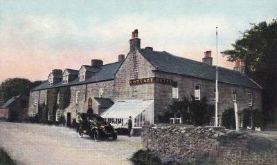
Cottage Hotel – Wooler (now The Tankerville Arms) c.1905
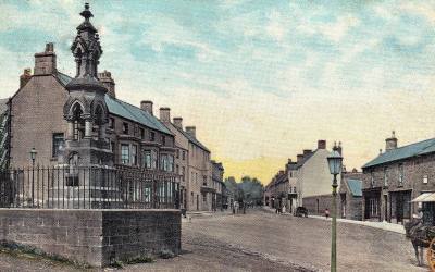
By the 19th century, Wooler had become a prosperous market town (population of 1911 in 1851), with agriculture providing the basis of the economy. During the first week of May the Hirings, a market and fair, used to take place on Wooler Market Place. Workers gathered alongside the now demolished fountain hoping to be hired for a year’s employment by farmers or estate managers. If chosen, a year’s contract would follow and the next year the same procedure would be repeated, thus creating much movement (flitting) between farms and houses. Hinds (farm labourers) needed to have a bondager (female worker) to help on the farm, and she would be paid by the hind.
Famous people connected with Wooler include the Dalziell Brothers, who were important engravers on wood, and illustrators, and were responsible for engraving block illustrations for Punch magazine. Sir Walter Scott is said to have visited in 1791 for health reasons, staying in a farmer’s house in the Cheviot Hills, Wooler being well known for its clean air and as a health resort. The young Grace Darling (1815-1842) also spent time in Wooler in an attempt to cure her consumption. Josephine Butler (1829-1906) social reformer, retired to Queens Road, Wooler where she died in 1906. Wooler W.I. erected a memorial plaque to her which said “Her works do follow her”.
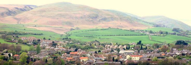
Wooler in the Cheviots. Photo: John Box.
Because of its proximity to the hills Wooler is known as “The Gateway to the Cheviots”, with the Cheviot Hills, Humbleton Hill, Hedgehope, and Harehope being favourites among walkers. Less strenuous walks include Wooler Common and the Pin Well (a natural spring). It was traditional for visitors to make a wish at the Pin Well by dropping bent pins into the well on May Day; today pins or coins can sometimes be seen in the well indicating that this custom has not been forgotten. The Pin Well is overlooked by The King’s Chair on The Kettles, a prehistoric camp. Surrey House on the A697, now quite derelict, was so called after the Earl of Surrey supposedly stayed there the night before the Battle of Flodden in 1513. It is said that this is where Surrey wrote to James IV reproaching him for not yet giving battle. Another place of interest is the Wooler Tower (or ‘The Tory’) situated on Church Street. There is little left of the mediaeval tower which during the middle ages was a motte and bailey castle. By 1526 a new tower had been erected and in 1545 it contained an important garrison. Even in its current neglected state it is well worth a visit to see the war memorial and its interesting views. The original castle belonged to the Muschamp family.
In 1887, the North Eastern Railway opened a single-track railway line between Alnwick and Cornhill, where it joined the Tweedmouth to Kelso line. Wooler was the most important intermediate station on the line, with a large goods yard and warehouse. It also had two separate platforms, a footbridge, and station waiting rooms on both sides. Initially the line served both passengers and freight services, but after World War I its passenger use declined, and from 1930 the line was operated for freight only. After the line suffered serious storm damage in 1948 and 1949, the cost of repairs could not be justified by the usage, and the line was divided into two with one segment running between Wooler and Coldstream. This survived until 1965 when it succumbed to the Beeching cuts, along with the Tweedmouth to Kelso line. Some of the station buildings at Wooler survive today. From 1936 the waiting room was used as a Youth Hostel, with separate accommodation for male and female on opposite sides of the tracks. The stationmaster’s house is now divided into two residences, and the goods warehouse is used by an antiques dealer.
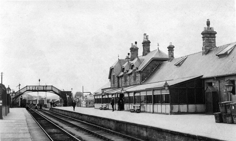
Wooler Station 1910. The station building on the right of the picture still stands. Photo: anon. John Alsop collection A 5353.
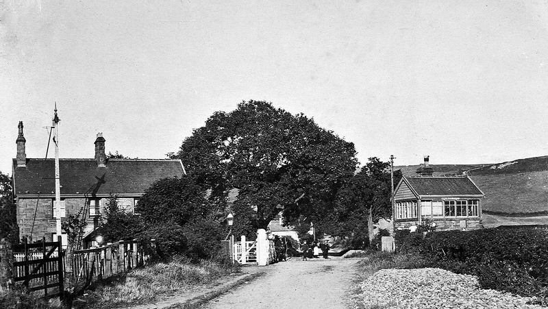
Brewery Road Wooler, showing the old signal box and level crossing. Photo: anon. John Alsop collection A 98466.
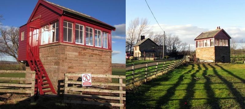
The restored Bendor Crossing Signal Box near Wooler, on the now defunct Alnwick to Cornhill railway, was built in 1887. The adjacent house pictured on the right-hand image was the original Crossing Keeper’s House. Photos: John Box.
In the early part of World War II, the Women’s Land Army stayed in the station buildings, until in 1941 they were re-billeted to a new building on Cheviot Street. Of their experience, the women said that, in spite of the hard work, they “wouldn’t have missed it for the world”.
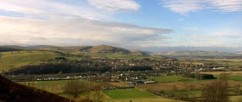
Wooler today
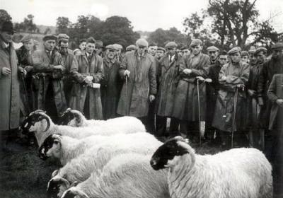
Photograph of shepherds watching the Shepherd’s Ewe Class at Glendale Show in 1957. Left to Right : Jim Inglis, Weetwood Hill; Jim Scott, Dunsdall; Alan Rogerson, Commonburn; Robin Mathieson, Langleeford; Bob Brown, Caloust; Dick Snaith, Debdon; Jim Wilson, Wooperton; Herbi Hornsby, Langleeford; Mat Little, Fleehope; Joe Stuart, Uswayford; Jef Little, Cocklawfoot; Jim Beatie, Akeld Hill; Walter Little, Cocklawfoot; A. Balmbro, Fleehope; Henry Tunnah, Mount Hooley; Bob Stuart, Hagdon; Jack Telfer, Kirknewton. (BRO 1760/1) Courtesy of Berwick Record Office.
The town today consists mainly of the high street with a variety of shops whose frontages are little changed from Victorian times. There are four churches – St. Ninians Roman Catholic Church, St. Mary’s Parish Church, The United Reformed Church and The Evangelical Church. Apart from normal religious meetings these churches have become multifunctional as venues for social gatherings, musical & charity evenings, and art exhibitions, and are all interesting buildings in their own right. Currently there are five public houses, these having dwindled over the years from thirteen in 1855 to the remaining five which are: The Black Bull (an old coaching inn), The Angel Inn, The Anchor Inn, The Red Lion and The Tankerville Arms (formerly the Cottage Hotel).
The Cheviot Centre and Information Centre is part of the original workhouse and has become the focal point of the town. The Glendale History Society and the U3A hold meetings here and a new library is also incorporated within the building. There are recently acquired wooden pods available for hire by small businesses.
High spots of the year include the Glendale Show with its many stalls (food, crafts, jewellery, etc.) the judging of animals, races, and a fair; it is a popular event and is visited by thousands of people. The Chevy Chase is a walk/run which takes place early in July and is a twenty mile race; it starts at the top of Ramsey’s Lane, finishing at the Y.H.A. The Wooler Festival is also an annual success with its food and craft stalls, clog and morris dancing, bands, folk music, Punch & Judy, and celidh. The Wooler Wheel cycling event has become another important date in the cycling calendar in North Northumberland with distances of 100K and 160K. Wooler is also on the route of the St. Cuthbert’s Way, a 100K long distance trail starting in Melrose and terminating on Lindisfarne.
Sources
Northumberland Place Names, by Stan Beckensall (1992).
Wooler, Ford, Chillingham & The Cheviots, by Frank Graham (1976).
Castles of Northumberland, by Brian Long (1967).
The Women’s Land Army: the Forgotten Army, by Hilary Briggs (Glendale Gateway Trust, 2004).
Highways and Byways in Northumbria, by Peter Anderson Graham (1920; 1988).
Disused Stations: site record: Wooler.
The banner image at the top of this page is taken from a photograph by Lisa Jarvis [CC-BY-SA-2.0, via Wikimedia Commons ].
********************
Further topics
In the 1830s, a number of families from Wooler joined emigration parties to settle in Canada, at Stanley and Harvey. More about their story can be found on the page about New Brunswick settlers.
For centuries gypsy families of North Northumberland and the Borders have played a significant part in community life.
|
The Wooler Floods of 1906 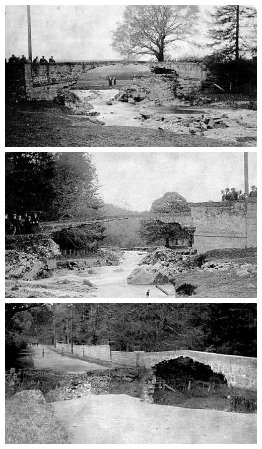 Lilburn Bridge 1906 On Saturday 19th May 1906, Wooler and the surrounding district suffered one of the worst storms in living memory. The weather had been cold with snow covering the Cheviot Hills; sleet and rain had fallen for days with the rain becoming a torrential downpour all day and night on the Saturday. The burns and hill streams rapidly became rivers, with the River Till overflowing its banks, and the whole of the low-lying area of Milfield plain was covered in flood water.
From all parts of the area came the news of severe damage. The Lilburn Bridge, which spanned the high road to Alnwick near Ilderton station, was undermined with the ever-increasing volume of water and fell with a crash just before midnight on the Saturday night. Masonry from the bridge was completely washed away, leaving only the two sides of the bridge and rendering the road completely impractible.
The railway line from Alnwick to Berwick was partially under water with the last train on the Saturday night terminating at the small station of Akeld. On the Sunday morning a gang of railway repair workers were drafted in to repair the line.
Many of the high roads were ploughed up and the stones laid bare by the rushing water, with damage to dykes and fences being considerable. The prospects for the landowners were drear with sheep being drowned by the score; horses were left stranded on islands in the fields created by the floods, their owners swimming out to rescue them in fear that they may perish in the flood waters. Whole fields of spring wheat lay ruined beneath an accumulation of silt and rubbish. Young game life also suffered during the extreme weather.
To put the storm into context, the amount of rain that fell during the whole of the previous year in the Wooler area was 27 inches; between the Wednesday and Sunday of the storm 5 inches of rain was registered.
Source: The Berwick Advertiser, May 25, 1906 Photographs of Lilburn Bridge: Derek Fairnington |